| Name
of Ford |
River and
Location |
|
Blackwell Ford |
On Mountain Creek
at the upper end of the William Hennessee Land. |
|
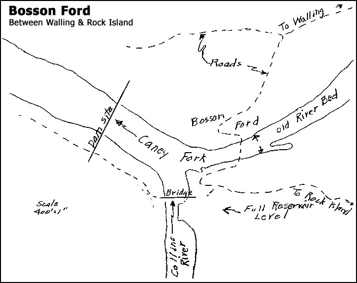
Bosson Ford |
Caney Fork just
above mouth of Collins River. (see
above map) |
| Blacks
Ford |
On Collins River
about 1 mile above bridge on Highway 70S. |
|
Bright's Ford |
On Rocky River near
the mouth of Laurel Creek. |
| Butts
Ford |
On Caney Fork 1/2
mile below mouth of Lost Creek [Webmaster's
note: also known as "Wallace Creek or Branch"]
and just above Butts Bridge (built in 1924). This is a
very old ford and was an Indian crossing coming down Hickory
Valley from Sparta, crossing Caney Fork and then following a
southeasterly direction up the mountain and across Glade Creek. |
| Byers
Ford |
On Collins River
near the present highway bridge on Highway 70S. |
|
Chattanooga Ford |
On Caney Fork a
short distance below the Mitchell Ford and about 1/4 mile down
stream from the Mitchell Bridge, at the lower end of Big Bottom.
It was possible to cross here and then take a road crossing at
Butts Ford with a fairly direct route to Pikeville and
Chattanooga. Webmaster's
notes: According to Bonnie V. Dycus (December 26, 2003),
who lived most of his life within a mile of this ford,
the Chattanooga Ford got its name from a Chattanooga-based
logging operation that set up at this location in the early
1900s. Logs were cut up the river and floated down to this
point, to be loaded on trucks and hauled to Chattanooga. |
|
Cummings Ford |
On Caney Fork just
below Cross Rock Spring, Reno Mill and the Reno Bridge. In
the first bend below the bridge. |
|
Cunningham Ford |
On Collins River a
short distance downstream from the Intake for water for the
Power House. James McGiboney, born 1847, said it was hard
to get in and out of. It gave access to the land in the
bend between the Caney Fork and the Collins River and was
referred to as "The Wilderness." |
| Denny
Ford |
On Caney Fork just
below the mouth of Dry Branch. This branch comes in from
the left bank or Van Buren County side. |
| Dillon
Ford |
On Caney Fork about
1/4 mile above Walling Station. It was a very old crossing
used by the Indians coming South on the Chickamauga Path.
They also crossed the Caney Fork at Rock Island but Dillons was
a better crossing. |
| Drakes
Ford |
On Cane Creek a
short distance above the mouth of the creek near an old mill. |
| Dungeys
Old Ford |
On Caney Fork about
800 feet downstream from the mouth of Calfkiller River. It
was referred to in an 1849 grant to Simmons. Dungey
received a grant - Cert. 1807, Entered 1819, and surveyed 1820.
The Hodge Bridge carried the traffic in later years. |
| Flat
Shoals Ford |
On Collins River 3
1/2 miles from mouth and on old road from Rowland (now called
Campaign) to old community of Horseshoe Falls, to Keltonburg and
Smithville. This ford was in use long before 1826. |
|
Gilmores Ford |
On Collins River.
Mentioned in Grant to John Gribble in 1851 near a bend in the
river. Probably near the old Hennessee bridge site. |
| Greens
Ford |
On Calfkiller
River. Probably near Burroughs & Taylor Mill located East
of Cave, Tenn. |
| Gribble
Ford |
On Collins River.
Probably short distance down stream from Flat Shoals and on
Gribble land. |
|
Hash Ford |
On Rocky River, 3/4
mile above mouth and near Yost Bridge - abandoned in 1924.
See McClures Ford. |
| Head
Ford |
On Laurel Creek -
first crossing above mouth of Creek. |
| Indian
Ford |
On Rocky River -
See McClures Ford. |
| Isle
Ford |
On Collins River
about 6 miles above Shellsford. |
|
McClures Ford |
On Caney Fork River
close to the present Highway 70S Bridge. Myer, page 850
quotes, "One of the early grants on Caney Fork near Rock Island
calls for a line 'where the Chicamauga Path crosses the river at
McClures Ford (later called Hash's Ford), near McClure's battle
ground." Myer, quoting from Mr. Roberts refers to
"crossing he Caney Fork at Hash's Ford (know seventy-five years
ago as McClure's Ford)."
There was a ford at the location given above but it was a bad
one and little used. The main traffic crossed Caney Fork
above the mouth of Rocky River and then forded that river at the
Hash Ford which was called the Indian ford and McClure's ford.
The Hash Family lived almost within sight of the ford.
Mrs. Elizabeth Hash, born 1834 told Mrs. Jennie Hash Rucker that
McClure's ford was on Rocky River near the old Iron Forge.
It as also called Hash Ford. Other old people told her the
same.
Capt. Roberts was incorrect in the same statement when
he referred to the ford being "within three hundred yards of the
stone fort, built by early whites in the bend of the river,
where McClure's battle was fought with the Indians. The
stone fort was there when the first settlers arrived." No
mention is made of the Stone Fort in any of the three accounts
of the battle. (See Old Stone Fort.) |
| McElroy
Ford |
Caney Fork River a
short distance below where the Tosh Bridge was built. |
| Miller,
Joab - Ford |
On Rocky River
below the old Joab Miller Bridge. (See Miller Bridge for
further details.) |
|
Mitchell Ford |
On Caney Fork at
the lower end of Big Bottom and a short distance downstream from
the end of the backwater of the Great Falls Reservoir. |
| Mormon
Mill Ford |
On Caney Fork River
about 1/2 mile downstream from the Butts Bridge. |
|
Plumlees Ford |
On Caney Fork above
the mouth of Calfkiller River. Mentioned in an 1847 grant.
Also mention in a deed of 1841 referring to a ferry road and
Parker Still House. |
| Porters
Old Ford |
Probably same as
Butts Ford. |
| Purvis
or Paervis Ford |
On Barren Fork
River. |
| River
Hill Ford |
On Caney Fork River
at the mouth of Cane Creek. Crossed both Caney Fork and
Cane Creek. |
| Rock
Island Ford |
Caney Fork River.
See Bosson Ford. |
| Rowland
Ford |
On Rocky River near
old Iron Forge. See McClures Ford. |
| Scotts
Ford |
On Hickory Creek
slightly over 2 miles north of Viola and a short distance
downstream from the bridge on the Viola-McMinnville Road near
the old bridge. A very old ford on the old Elk River Road,
sometimes called the Alabama Road. |
| Shells
Ford |
On Collins River
about 3 1/2 air miles East South East of McMinnville on the road
to Little Cardwell Mountain. Ford and mill mentioned in
deed of 1886. |
| Simmons
Ford |
On Cane Creek just
above the mouth of Spring Branch. |
| Wallens
or Wallers Ford |
On Calfkiller
downstream from Harriett Iron Works which was located near the
dam constructed for the Hydro-electric plant. |
| Yorks
Ford |
On Laurel Creek a
short distance above York's Mill. |
| Yost
Ford |
Located near former
Yost Bridge and also called Hash Ford. See
Hash Ford and
McClures Ford on previous page. |