|
"South of the Holston River,
Opposite Knoxville"
(from sometime in 1790s to 1802 or a bit later)
There is clear evidence to prove that Daniel and his family lived,
at least for several years," south of the Holston
River, opposite Knoxville."
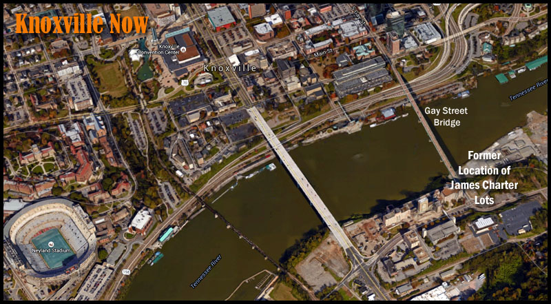
Note: The river that flows south of downtown Knoxville is
now known as the Tennessee River (specifically, it is now "Fort Loudon
Lake on the Tennessee River"). Previous to 1874, the part of the
river that was east of Kingston, TN was known as the Holston River.
Source: Goodspeed's
History of Tennessee Illustrated: Knox County (1887)
The Fort Loudon dam, a few miles southwest of
Knoxville, was completed in 1943. Prior to that time the
Tennessee River ("Holston River" prior to 1874) would have looked
somewhat different and flowed differently, compared
to the way it appears and flows now. The river in that area now is the
backwaters of Fort Loudon Lake. Thus, in general it is now a bit wider, deeper, and appears to flow more slowly than it would have prior to the
creation of the lake.
Summary of the Evidence Stated Below
|
Where did Daniel
Haston's family live in Knox County, TN?
Daniel Haston and family lived
"south of the Holston River, opposite Knoxville" on a lot (or
lots) rented
from John and Mary Wood of Maryville, TN (although we have found
no documents indicating the Woods' ownership of the lots).
At the time Daniel's family lived there, apparently James Charter managed
the rental of the lots for John and Mary Woods.
But by 1807 the lots were owned by James Charter.
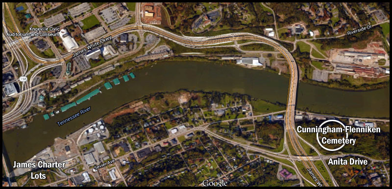
Beginning in July of 1792, a ferry
ran from the south side of the Holston River, near where the
south end of the Gay Street bridge (not built until 1898) is now
located, to near the mouth of First Creek on the
north (Knoxville) side of the river. The ferry was
originally owned by Alexander Cunningham. On page 140 of his journal,
Richard Green Waterhouse, who operated the ferry for several
years, called the south landing the "Flat
Landing." The terrain at that point, even today,
is "flat" when compared to most other locations up and down the
river.
James Charter managed, and later
owned, a lot adjacent to the ferry landing, a second lot
adjacent to the first lot, and a third lot adjacent to the
second lot. Daniel Haston and family lived on one (or
more) of these lots. So, the Hastons lived just across (south of)
the river from downtown Knoxville, approximately one-half mile away
from
the heart of town--and, less than a mile up and across the river
from the current site of the football (Neyland) stadium on the
campus of the University of Tennessee.
From the ferry landing, one road
ran southwesterly toward Maryville in Blount County and another
road ran southeasterly to Sevier County. Daniel's family,
apparently, was situated very near the fork of those two roads.
When John Sevier was (the first)
Governor of the young state of Tennessee (1796-1801 and
1803-1809), the state capitol was Knoxville (1796-1812).
John Sevier regularly crossed that ferry and traveled one of
these roads to and from his "Marble Springs" farm. In
so doing, he would have passed the Daniel Haston home on every
trip. There is an entry in his diary that seems to
indicate that John Sevier knew and interacted with members of
the Daniel Haston family. |
|
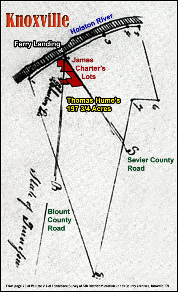
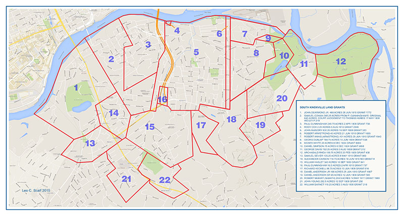
Survey Notes
Thomas Hume Survey -
In Knox County on the Holston River, south of French Broad
and Holston. One hundred and ninety-seven acres and
three roods (3/4 acre). Note: This is the land that
Samuel Cowan had owned when Daniel Haston lived on the James
Charter lots.
-
Begins at a corner with
John Dearmond then up (north 43 degrees east 31 chains)
the meanders of river to the boat landing,
-
then north 49 degrees
east 33 chains,
-
then north 59 degrees
east 18 chains,
-
then north 71 degrees
east eight chains to corner with heirs of Paul
Cunningham,
-
then leaving the river
south 28 degrees east 57 chains,
-
then south 79 degrees
west 20 chains,
-
then south 134 chains (?
degrees west) crossing the road at 20 chains,
-
then north 30 1/2 degrees
west 152 chains to the beginning.
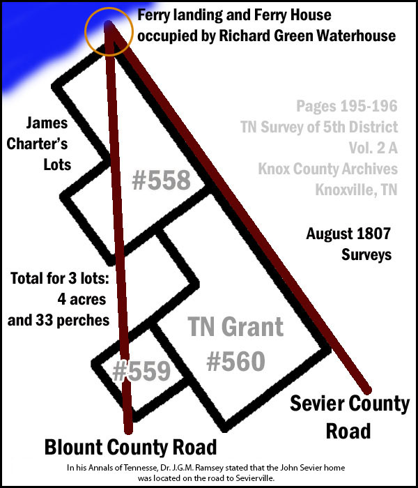
Grant 558 Survey - Begins
(upper-right corner) at stake near the corner of the house
that Richard G. Waterhouse lives in now (July 1807) and is
within one chain (33 feet or less) of the (ferry) landing.
One acre, two rood (1/4 acre), and 16 rods (1/10 acre).
Grant 559 Survey - Begins
(upper-right corner) at stake near the corner of an old
stable house. One-half acre and one perch (30 1/4
square yards). Perch is same as a rod.
Grant 560 Survey - Begins
(upper-right corner) at stake near the house William
Montgomery now lives in (July 1807) which may indicate that
William Montgomery lived in lot #558 at that time. Two acres
and 16 perches (1/10 acre). |
|
Acknowledgments
Much of the detailed
information that made this section possible came from people
who visited this website and contacted Wayne Haston to share their
research findings. Roy Coker and Skip (Leo)
Scalf, in particular, did an excellent job researching
and mapping the deeds of the area "south of the Holston,
opposite Knoxville" - an area that Richard Green Waterhouse
(who lived there and operated the ferry) often referred to
as "Iredell."
My name is
Roy Coker and I made a grant map for Knox County south of
the French Broad and Holston Rivers based upon the 1807
Tennessee surveys. The James Charter lots you refer to in
your article are shown on a 1807 survey for Thomas Hume.
The Hume survey
contains a large tract of land on the Holston River with
James Charter lots located on the River bank with two roads
intersecting at the river bank at the lots. The lots are
excepted from his survey. Thomas Hume's survey
joined Paul Cunningham Sr. 249 acre TN survey on the west.
I have a 1790 North Carolina survey for 300 acres for Paul
Cunningham on South side of Holston River (granted in 1795).
The 1790 Cunningham survey appears to include the top half
of both Tennessee surveys - Thomas Hume and Paul Cunningham
1807 surveys. These two roads on Hume's survey are labeled
"B" and "S"- probably Blount Road (Maryville Turnpike) and
Sevierville Road or Pike. (Roy Coker, August 17,
2010 email)
Thomas Hume survey's
western boundary at the river is near where Gay Street
bridge in now located. The
landing at the intersection of the two roads where the James
Charter lots are is 31 chains up the river (northeast).
That would be 1023 feet up river from Gay Street Bridge.
Note that the survey chain used in this area is a mountain
chain equal to 2 rods= 33 feet, not the standard chain of 4
rods= 66 feet. The land would be across the Holston River
(now TN River) from 1st Creek- Blount Mansion & James White
Fort. The three James Charter lots combined were 4 acres &
33 perches. The Hume survey was 201 acres less the Charter
lots = 197 acres and 3 rods.
The three lots of James
Charter are TN grant # 2028 for 1 acre 2 rods & 16
(perches?) described as opposite Knoxville beginning near
house where Richard G. Waterhouse now lives within one chain
of landing. TN grant # 2029 for 2 acres 16 perches near
house of William Montgomery, and TN grant # 2030 for 1 acre
2 rods & one perch beginning opposite or near an old stable.
It appears from the 1790 Paul Cunningham Sr. North Carolina
survey of 300 acres (granted in 1795) that survey included
the top half of both the Thomas Hume and Cunningham 1807 TN
grants.
My ancestor Warren Coker
married Polly (Mary) Cunningham in Knox Co. in 1808. I
believe that Polly is a grand daughter of Paul Cunningham
Sr, perhaps daughter of James or Alexander Cunningham. You
refer to a Old Cunningham Cemetery on Magazine Street in
South Knoxville. Paul Cunningham 3rd, grandson of Paul
Cunningham Sr., owned land at and south of the intersection
of Magazine Road and West Ford Valley Road. William
Coker Sr. brother of Charles Coker Sr. had a 1792 survey of
400 acres on South bank of Holston shaped like a horseshoe
now owned by University of TN. Alcoa HWY crosses it. All
of this land was resurveyed in 1807 and new TN grants
issued.
My ancestor Charles Coker
Sr. died in 1799 and never received a grant for his land.
His widow Judy Coker probably didn't have enough money to
get a 1807 survey and grant. You refer to a John & Jane
Wood who leased land to your Daniel Haston. I do not know
what kind of title Woods would have had on property.
Perhaps there are some records related to this property in
the parent counties of Knox? (Roy Coker, August 18,
2010 email)
You
inquired about a John Dearmond Jr. on your site. The large
grant that joined Thomas Humes 1807 TN survey on Hume's west
boundary belonged to John Dearmond Jr. I believe the
Tipton's lived on Stock Creek- south side of Holston &
French Broad. William Johnson a well known Baptist minister
also lived on Stock Creek - he was probably one of the
jurors in one of the cases you mention on your site. A
Roddy Cox had a 37 acre survey on Knob Creek joining Charles
Coker (Jr.) in 1807. There is a county court minute (no
date - but abt. 1810) where a Rhoda Cox property of 37 acres
is levied by court to be sold - where she now lives. This
is a type script page 132 (pg 166 original). The case is
Jacob Teener (Keener?) and Elizabeth Huntsman Administrators
of John Huntsman deceased vs. Rhoda Cox and Jacob Huntsman.
Looks like you have
found where your Daniel Haston Lived. I
would bet those James Charter lot grants were from property
he acquired from Samuel Cowan. I think it likely that
Thomas Hume bought Samuel Cowan property (except lots) and
later got TN grant for it. Cowan probably acquired it from
Cunningham. The estate papers of Paul Cunningham Sr.
guardian (James White) account for his minor Samuel H.
Cunningham refer to the cost of a court case for the grant
land. So does the guardian (Samuel Flenniken) for Paul
Cunningham (3rd) and Margaret his sister- children of Paul
Cunningham Jr deceased.
As soon as the grant was
issued to the heirs of Paul Cunningham Sr in 1810, they sold
it to Thomas Hume neighbor on their west boundary. This
case would have been between 1805 and 1810. (Roy
Coker, August 18, 2010 email)
I have been
researching the property in my area along the Tennessee
River from the forks to third creek. In doing so I have
found a deed conveying the estate of Samuel Cowan. I believe
that it indicates where Daniel Haston possibly rented from
James Charter. (Leo "Skip" Scalf, June 22, 2015
email - on July 1, 2015 Wayne Haston visited Skip Scalf in
his south Knoxville home and he shared some very significant
information regarding the "south of Holston, opposite
Knoxville" area - including a preview of his deed map of the
area.) |
Deed Map created in 2015 by Leo C. (Skip) Scalf (skip@scalf.com)
- Knox County, TN Road
Order Book, 1792-1819 (available on microfilm at the Knox
County, TN Archives in Knoxville; also, available at the Lawson McGhee
Library in downtown Knoxville, TN)
On page 18 of the Knox County, TN Road Order Book
(1792-1819) Daniel Haston is mentioned as a member of a road jury
made up of men who are known to have lived adjacent to or near each
other in the area of Knox County, "south of the Holston River,
opposite Knoxville." Court records (see below, as well as the
Daniel Haston timeline)
indicate that Daniel Haston had dealings with Paul Cunningham,
Nathaniel Hays, and James Charter on other occasions.
The following persons were appointed as Jury to
wit, Paul Cunningham, Nathaniel Hays, Francis Cunningham, Daniel
Hastings and James Charter, for the purpose of reviewing a road from
the new Ferry landing on the south side of Holston opposite to
Knoxville unto the old road leading to Tellico Blockhouse, to report
to next Court whether any disadvantage doth arise to the Citizens
from the alteration and whether any disadvantages would arise from
making the old landing and road so far as to where the new road
strikes it obsolete.
Who at the October Sessions reported as
follows.
We the Jurors appointed to view the Road from the new ferry landing
with the old Tellico road, and Boyds Creek road being met and duly
sworn to report as follows, to wit. From the new landing with the
Boyds creek road to the farthest corner of Charter's lots, and along
the end of said lots, thence as the old waggon road runs to where a
heep of bark is piled in the road, and conceive no disadvantage by
attesing (?) the landing. Signed by the Jurors.
[Note: This must have been copied by a clerk from the original
document written by the jurors, since no jury signatures are found
here.]
Daniel Haston lived on one
of the lots referred to above as [James] "Charter's lots."
- Knox County,
TN Court Case File: Docket # 1385/1235, Samuel Cowan vs Joseph Hasting
(1800-1801) [Also: Pages 76-78 of WPA transcribed Records of
Knox County, TN Minute Book, No. 3, 1800-1802]
This court case, which began early in 1800, states clearly that
Daniel and Joseph Haston lived
"on the South side of Holston
River opposite Knoxville." At this time, Daniel Haston was
living on land rented from John and Jane Wood (or Woods) of Maryville,
TN (Blount County) and the Woods' agent was James Charter. This
land was adjacent to land owned by the plaintiff, Samuel Cowan, a well
known merchandiser in Knoxville.
To this point, we have been
unable to locate a deed or survey for the "south of the Holston,
opposite Knoxville" land owned by John and Jane
Wood. If you have documentation regarding these pieces of
property, please contact us.
But we do have documentation that James Charter owned three lots in
this area in 1807 (most likely lots that he earlier had managed for
John and Jane Woods).
Samuel Cowan, the plaintiff
in the case, at that time, owned the ferry that crossed the Holston River at the
southeast corner of Knoxville. This is the same ferry that
Richard G. Waterhouse leased from the heirs of Samuel Cowan in January
of 1803, a couple of years after the conclusion of the Cowan vs Haston
case and the death of Samuel Cowan. In
his journal (page 136 and
elsewhere), Waterhouse* referred to this area, just across the Holston
from Knoxville, as the Iredell community.
|
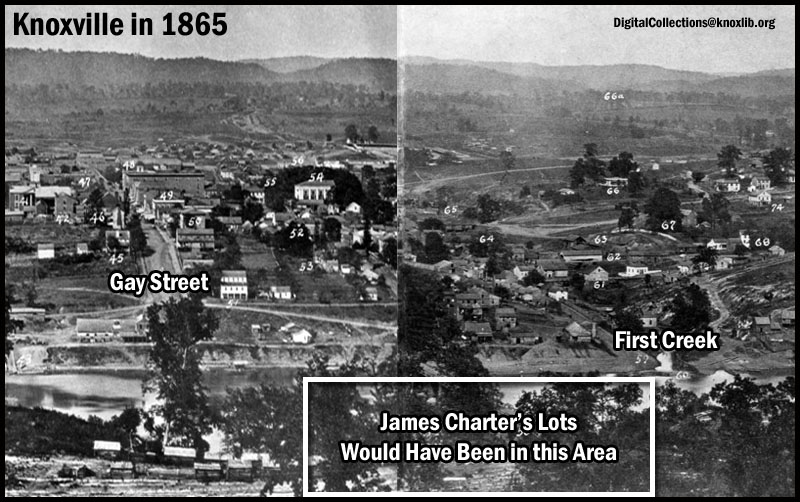
Why was this area
known as "Iredell" in and around 1800?
The founder of Knoxville, James White, was born in the
part of North Carolina that became Iredell County in
1788. Perhaps (?) James White named the area
"Iredell." He was an early owner of land
in that area.
Other than the numerous
references to "Iredell" in Richard Green Waterhouse's
journal, we have found no other sources that use the
Iredell name to refer to this "south of the Holston,
opposite Knoxville" area.
If you have additional
information about the "Iredell" area south of Knoxville,
or the reason for it being called that, please contact
Wayne Haston. |
James Cunningham, son of Paul
Cunningham, Sr., was summoned to witness on behalf of Joseph Haston.
This Cunningham family was known to have lived in the area described
by that phrase.
James Charter (agent for Jane and John Wood)
also owned property in this section of Knox County (see page 140 of
the Richard G. Waterhouse
journal). Possibly or probably, by this time (December 1804)
James Charter owned the lots that formerly belonged to John and Jane
Wood.
*Richard
Green Waterhouse (1775-1827): Tennessee Pioneer by Elizabeth
Waterhouse Layman. Wolfe City, TX: Henington Publishing Company, 1996.
-
State vs David Haston & Joseph Haston; Knox Co, TN County
Court of Pleas and Quarter Sessions; Docket # 796/65 (1798)
Circumstantial evidence in
this case would suggest that the Haston family lived in the same area,
in late 1797, where they lived later, in 1800.
Nathaniel Hays, the
plaintiff, in this case was known to have lived in south Knox County,
south of the Holston River. Also, two of the witnesses who were
called to testify for Hays, William Haslet, Jr. and William Haslet,
Sr., were known to have lived in this area south of the Holston.
The case summary mentions
that William Haslet, Jr. "rode in to the Island" to track the blood
of the cows whose tails David Haston was accused of cutting.
Was this an island covered when Fort Loudon Lake was created in the
early 1940s? Or, could this be the large island a mile or so
up river that is now called Dickinson's Island, where an airport for
small planes now exists?
- Governor John Sevier's Journal
"After Tennessee became a state on June 1, 1796, the
Governor was required by law to live in the capital; however, his
family did not arrive in Knoxville until the following year."
"Governor Sevier liked farm life, and did not agree with most
residents of the capital city that log houses were passé. He purchased
a plantation south of the river, not far from his former militia
headquarters near the Indian towns, and christened it 'Marble
Springs.' There he built a log house very similar to Plum Grove (his
Washington County home), and surrounded it with outbuildings."
Source: Page 49 of Knoxville by Betsey Beeler Creekmore,
published 1991 by the East TN Historical Society
John Sevier's Knox County plantation was located south of the
Holston, opposite Knoxville, approximately 4.5 miles from the home of Daniel
Haston's family. Numerous references in the John Sevier journal
suggest that John Sevier and Daniel Haston lived in the same general
neighborhood.
- Tuesday, June 23, 1796: "Mr. Haislet Junr.
reaped part of the day. Haislet Senr. a whole day."*
Note: These are probably the men (William Haslet, Jr. and
William Haslet, Sr.) who witnessed against David Haston in the
1797-1798 Knox County
"cow tails" case.
They, almost surely, were Knox County neighbors to the Daniel Haston
family in late 1797. However, it appears that, on this date,
John Sevier was reaping on his Plum Grove plantation on the Nolachucky
River, about ten miles from Jonesboro, TN, a plantation that he
continued to own after moving to the Knoxville area. *Source:
Journal, page 188
- Friday, August 12, 1796: "Let
Suza Haiston have 1 dollar recd. from her
melons &c to the amt. of 4/."* The journal seems to indicate
that Governor Sevier was in Knoxville at the time of this payment to
Suza Haiston. Was this Suza a member of the Daniel Haston
family? Perhaps he purchased
vegetables from them and Suza stopped where he was staying at the
time, in Knoxville, to collect what he owed or delivered vegetables to
him. Or, perhaps John Sevier paid her as he passed the Haston home
on the way to his Marble Springs farm. *Source: Journal, page
189.
Note: On Thursday, October 20, 1796, John Sevier "paid unto
Mrs. Hairston 3 dollars in full of all accompts." (Journal,
page 191) Was this "Mrs. Hairston" the same lady as "Suza
Haiston?"
- To travel from Knoxville to his Marble Springs
plantation, John Sevier apparently took the ferry that was originally
owned by Alexander Cunningham, then later by Samuel Cowan, and later
by Richard G. Waterhouse (and others later). This ferry landed south of the Holston
very near where the Haston family lived.
Both Samuel Cowan and a member of the Cunningham family (James
Cunningham) were associated the "timothy lot"
court case
involving land where the Hastons lived. According to his
journal, Sevier paid "Roddy the
ferryman 15s 4d" on Wednesday, December 5, 1798 (page 255) [Also,
May 6, 1799 & January 10, 1800]. Was this one of the
Roddys with
whom the Daniel Haston family was associated? He must have been
employed by Samuel Cowan who owned that ferry at the time of these
entries.
Source of Cunningham-Cowan-Waterhouse ferry information: Tennessee
Anthropologist, Volume XVI, Number 2, Fall, 1991.
Source: Journal of
Governor Sevier (1790-1835) as transcribed by John H. Dewitt
and published in the Tennessee Historical Magazine on pages
156-194 in Volume 5, #3 (October 1919) & on pages 232-264 in Volume 5,
#4 (January 1920) & on pages 18-67 in Volume 6, #1 (April 1920).
|
John Sevier's Regular Commute from
Home to Knoxville and Back
At one point, John Sevier began to build a house
("mansion") in Knoxville, but ran out of money and gave
up the idea because he disliked debt. He sold his
lot and unfinished house and...
...retired to his farm, where he ever afterward
lived, making his home, when obliged to be in Knoxville
on official business, with his son-in-law, Major
McLellan....
Near the main road leading to Sevierville*, and
about five miles from the city of Knoxville, in a
deserted and worn-out field, are the ruins of an old log
station [as of 1887].
It was in a secluded and picturesque region, where
a copious spring gushes forth from a spur of Bay's
Mountain. The surrounding land was bought by
Sevier when, about 1790, he took up his abode on the
frontier, to be nearer to the hostile Indians. The
buildings he at once enlarged, and he kept on adding to
them year by year--one log-house being tacked to
another--till the structure more resembled a hamlet than
a single dwelling.
Here he lived
ever after his futile effort at building a town mansion,
in a style of rustic simplicity, going into town about
every morning, and returning at night, and always on
horseback....
Source: Pages 309-310 of John Sevier as a
Commonwealth Builder by James R. Gilmore (reprint
from the original 1887 edition).
*In his Annals of Tennessee, Dr. J.G.M. Ramsey stated
that the John Sevier home was located on the road to
Sevierville. |
|
John Sevier and Daniel Haston from
Same Area of Virginia
John Sevier and Daniel Haston came from the same area
in the Shenandoah Valley of Virginia. John
Sevier's father owned a tavern in what developed into
New Market, VA--where John Sevier was
born in 1745. Daniel Haston (born about 1750)
grew up east of the Massanutten Mountain from New
Market, VA (near what is now Luray, VA)--about 10 miles
away. Later, as a young adult, Daniel lived on top
of the Massanutten Mountain in Powell's Fort Valley and
New Market would have probably been the closest market
town to him, at that time--about 10 miles away.
And Daniel's wife, Christina Nave, and her family lived
less than four miles north of New Market on the valley
road. Thus, it is very possible that Daniel Haston
and John Sevier were acquainted prior to John Sevier
moving away from New Market, to the Holston River Valley
of what became Tennessee in the early 1770s. |
- Cunningham Family Evidence
There is abundant evidence (Knox Co, TN court
records, deeds, etc.) to prove that there was a well known Cunningham
family that lived south of the Holston and opposite Knoxville in the
1790s and early 1800s. The progenitor of this family was Paul
Cunningham, who was one of the original commissioners of Knoxville and
died on March 8, 1805 in Knox County.
According to Cunningham researcher, Sharon Webb,
Paul Cunningham "settled across the river, about three miles from
Knoxville." She also states that his "final resting place is in
a family cemetery overlooking the bluffs along the Tennessee River in
South Knoxville." Source: "Cunningham Family and Paul
Cunningham Letter (Knox Co, TN, 1796)," an article in the December,
2002 issue of Tennessee Ancestors (Volume 18, Number 3).
Location of Cunningham Family Cemetery
- South Knoxville, TN
|
 |
The same Nathaniel Hays who
took David Haston to court in the
"cow tails" case, took Paul
Cunningham to court for a dispute regarding property boundaries.
The Hays vs Cunningham case reveals the
following information regarding where these neighbors of Daniel Haston
lived:
- Nathaniel Hays
- South side of the French Broad River, property
line began on the river bank
- Adjacent Paul Cunningham, Senior
- Adjacent to Archibald Rhea lands
- Paul Cunningham, Senior
- Near Knoxville
- South side of the Holston River, property line
began on the river bank
- Some "rock house" on the Holston was a marker
point
- Near, but does not cross the Meadow Branch
- Adjacent to William Haislet
- Adjacent to Cowan; along this line to the river
- Originally called the Baker improvement
- Purchased from James White in mid-1780s
Nathaniel Hays and Paul Cunningham had been involved
in a previous (1800-1801) Hamilton District Superior Court case (Nathaniel
Hays vs Solomon McCampbell and Paul Cunningham) involving a
similar property boundaries suit. From the narratives of that
case, we can learn more about the land that they possessed:
- Nathaniel Hays purchased his land from Solomon
McCampbell in 1792.
- Hays land was on the south side of the Holston
(as well as south of the French River, as per the Hays vs Cunningham
case). It seems that the banks of both of those rivers formed
part of his property lines. His land met the property lines of
Haislet and Archibald Rhea on the river bank (seems to refer to the
Holston River bank).
- His land was only about 1 1/2 miles from
Knoxville (as was the home site of Paul Cunningham).
- Paul Cunningham purchased his land (640 acres) in
1785 from James White, who had purchased it from a Captain Baker.
Paul Cunningham then sent his sons, Alexander and James, to improve
it and develop it.
Note: Alexander Cunningham started a ferry from this land
(that later was sold to Samuel Cowan and later to Richard G.
Waterhouse, and others later). This was the ferry that John
Sevier used in his trips from Knoxville to his plantation home,
which was located in this south of the Holston, south of the French
Broad area.
- Cunningham's land had about 500 feet of frontage
on the Holston River.
- Paul Cunningham moved his family to this land in
December 1797.
- Cunningham's land adjoined Haislet land along a
"Meadow Branch" which belonged to Haislet.
- Journal of Richard G.
Waterhouse
Richard Green Waterhouse (1775-1827): Tennessee Pioneer by
Elizabeth Waterhouse Layman (Wolfe City, TX: Henington Publishing
Co, 1996).
Although the Richard G.
Waterhouse (RGW) journal does not mention Daniel Haston nor any of
his family members, Waterhouse lived in this "south of the Holston,
south of the French Broad" area and operated the ferry that was
started by Alexander Cunningham. He often referred to the area
as "Iredell." His sojourn in this specific area overlapped
that of Daniel Haston for approximately four years. They had
several (probably many) common acquaintances and lived near each
other, thus they must have known each other fairly well.
- RGW had dealings with James Charter, who was
John & Mary Wood's land agent and was mentioned in the Samuel
Cowan vs Joseph Haston
"timothy lot"
case.
- He had many very close dealings with the sons
and daughters of
Phillip & Mary McComesky Roddy.
- Rented the ferry owned by
Samuel Cowan,
before his death (ferry originally owned by Alexander Cunningham).
- He had close dealings with the William
("Fighting Billy") Tipton family and married his daughter, Polly.
William
Tipton was one of Daniel Haston's securities for the James
Roddy estate settlement.
- Buried his son in "Mr. Cunningham's Burying
Ground." This was probably the family cemetery on John
Cunningham's property, as described in Sharon Webb's article (see
above). If so, it overlooked the Holston (Tennessee)
River on a bluff across the river from Knoxville.
|
The Ferry from Downtown Knoxville
to "South of the Holston, Opposite Knoxville"
Some Key Facts:
-
At Tennessee River mile 647.8 (where
the
Star of Knoxville Riverboat Dock is now located)
-
Early owners:
-Alexander Cunningham (July, 1792)
-Samuel Cowan (January, 1798)
-Richard Waterhouse (1803) - Waterhouse called it
"the public ferry" (maybe the only ferry)
-Robert Craighead (1805-1806)
-Thomas Humes (January, 1806)
-William or Samuel (?) Montgomery (by or before
1815)
-
The south side landing called "the
Flat Landing" by Richard Waterhouse, in his journal.
-
James White was allowed to run
another ferry, at the same location, but only from
north to south:
-James White (1795)
-Hugh Lawson White (January, 1798)
Sources:
- Tennessee Anthropologist, Volume XVI,
Number 2, Fall 1991. "Tennessee River Ferries"
article by Tony Holmes.
- Richard Green Waterhouse (1775-1827):
Tennessee Pioneer by Elizabeth Waterhouse Layman
(Wolfe City, TX: Henington Publishing Co, 1996)
|
|