|
The Caney Fork River -
Tributaries
The Caney Fork River has its start in a small stream
north of Pleasant Hill in Cumberland County, meanders a little west of
south, crossing Highway 70S 3 miles east of Pleasant Hill and continues
generally south to Pilot Falls where it drops from the Cumberland
Plateau into "The Gulf." The river then flows in a westerly
direction thru "The Gulf" and emerges from between the high mountain
walls at the lower end of Big Bottom, 26 miles up stream from Great
Falls. It continues west 3 miles beyond the Falls and turns north
continues with many a twist and turn to the Cumberland River a mile
upstream the town of Carthage. The river flows in a gorge from the
Great Falls for about 8 miles to below Franks Ferry when the valley opens up
and there are many fine fertile farm lands. Of course many of
these were flooded out when the Center Hill Dam was built.
Headwaters of many tributaries have their origin very
close to the eastern edge of the Cumberland Plateau in Bledsoe, Grundy
and Van Buren Counties. The Rocky and Collins Rivers also have
their start on the Cumberland Plateau and flow in a northerly direction
to the Caney Fork. The Barren Fork drains the eastern fringe of
Coffee and Cannon Counties and enters the Collins River about 1 1/2
miles above the bridge on Highway 70S.
The Calfkiller River rises on the edge of Monterey, flows
south and southwest to the upper Caney Fork. Falling Water rises
within less than a mile of the Calfkiller and flows west to the Caney
Fork entering about 33 miles below the Falls.
Tributaries in the following lists have been arranged
beginning at the mouth of the river and listing upstream. Right
and Left refer to the side of the river seen when facing downstream.
|
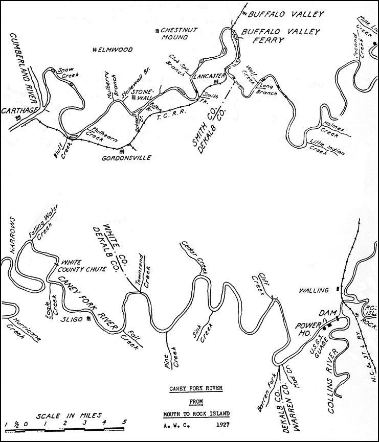
Caney Fork River
Tributaries Below Great Falls
Note: Numbers indicate order in which these tributaries
appear if you are going upstream from the river's mouth
near Carthage. However, "left" and "right" banks are
determined by facing downstream. |
| Left Bank |
Right Bank |
| Bluff Creek |
2 |
1 |
Snow Creek |
| Mulhearn Creek |
3 |
4 |
Mulberry Branch |
| Hickman Creek |
6 |
5 |
Stonewall Branch |
| Boulton's Branch |
7 |
9 |
Club Spring Branch |
| Smith Fork |
8 |
10 |
Indian Creek |
| Long Branch |
12 |
11 |
Null's Branch |
| Little Indian Creek |
14 |
13 |
Wolf Creek |
| Holmes Creek |
15 |
16 |
Second Creek |
| Hurricane Creek |
17 |
18 |
Mine Lick Creek |
| Eagle Creek |
20 |
19 |
Falling Water Creek |
| Fall Creek |
21 |
22 |
Townsend Creek |
| Pine Creek |
23 |
24 |
Cedar Creek |
| Sink Creek |
26 |
25 |
Cliff Creek |
| Barren Creek |
28 |
26 |
Rhode's Mill Branch |
| Mud Creek |
29 |
27 |
Saw Mill Branch
(Just above Frank's Ferry) |
|
|
Caney Fork River
Tributaries Above Great Falls
Note: Numbers indicate in which order these tributaries
appear if you are going upstream from the Great Falls
Dam. However, "left" and "right" banks are determined by
facing downstream. |
| Left Bank |
Right Bank |
| Collins River |
1 |
|
|
| Rocky River
(once called "Calhoun Creek") |
2 |
|
|
| Dry Branch
(mentioned in 1811 deed) |
3 |
4 |
Calfkiller River |
| Cane Creek |
5 |
6 |
Lost Creek |
| Bee Creek |
7 |
8 |
Clifty Creek |
|
Note: Pilot Falls is upstream
from Clifty Creek. |
| Big Laurel Creek |
10 |
9 |
West Fork |
| Beam Creek |
12 |
11 |
Polk Path Creek |
| |
|
13 |
Hood Branch |
|
|
Collins River
Tributaries
Note: Numbers indicate in which order these tributaries
appear if you are going upstream from the mouth of the
river. However, "left" and "right" banks are determined by
facing downstream. |
| Left Bank |
Right Bank |
| Mountain Creek |
2 |
1 |
Mud Creek |
| Charles Creek
(first known as "Chollee Creek") |
3 |
|
|
| Barren Fork |
4 |
|
|
| Gregory Creek |
5 |
7 |
Cope Creek |
| Town Creek |
6 |
8 |
Dry Spring Branch |
| Trayor Creek |
10 |
9 |
Cove Creek |
| Rain Creek |
12 |
11 |
Savage Creek |
|
|
Barren Fork
Tributaries
Note: Numbers indicate in which order these tributaries
appear if you are going upstream from the mouth of the
river. However, "left" and "right" banks are determined by
facing downstream. |
| Left Bank |
Right Bank |
| |
|
1 |
Hickory Creek |
| |
|
2 |
Little Hickory Creek
(1 mile north of Viola) |
| |
|
3 |
Snelling Branch |
| |
|
4 |
Mitchell Branch |
| Figgs Branch |
6 |
5 |
South Prong |
|
|
Rocky
River
Tributaries
Note: Numbers indicate in which order these tributaries
appear if you are going upstream from the mouth of the
river. However, "left" and "right" banks are determined by
facing downstream. |
| Left Bank |
Right Bank |
| Dyer Gulch |
2 |
1 |
Laurel Creek |
| Narrow Cove |
3 |
|
|
|
|
Calfkiller River
Tributaries
Note: Numbers indicate in which order these tributaries
appear if you are going upstream from the mouth of the
river. However, "left" and "right" banks are determined by
facing downstream. |
| Left Bank |
Right Bank |
| Wild Cat Creek |
2 |
1 |
Town Creek |
| Blue Spring Creek |
3 |
4 |
Cherry Creek |
| Rutledge Creek |
6 |
5 |
Plum Creek |
| Brush Creek |
7 |
8 |
Mill Creek |
| Whetstone Creek |
9 |
|
|
| Brady Creek |
10 |
11 |
Whilders Branch
(arises in Monterey) |
|
There are many other small streams and branches.
Some have names but the writer is not familiar with them.
|
Drainage Areas
|
|
Caney Fork River |
|
At Mouth |
2620 square miles |
|
Buffalo Valley
|
2269 square miles |
|
Center Hill Dam |
2195 square miles |
|
Silver Point |
2100 square miles |
|
Rock Island Dam |
1640 square miles |
|
Mouth of Bee Creek |
269 square miles |
|
Bee Creek |
122 square miles |
|
Cane Creek |
169 square miles |
|
Calfkiller River |
181 square miles |
|
Rocky River |
111 square miles |
|
Collins River |
|
|
At Henderson Bridge |
800 square miles |
|
Hgw. 70S Bridge |
624 square miles |
|
Barren Fork |
242 square miles |
|
Falling Water |
191 square miles |
|
Smith Fork |
216 square miles |
|
|