| |
| Arch Cave |
| Discovered in 1806 and located about 600 or
800 yards from Bone Cave according to Goodspeed's History. |
| |
| Armstrong, John |
| A grant to John Armstrong was entered in 1807
and surveyed in 1809, calling for 200 acres at the mouth of
Rocky River and both sides of Caney Fork including the
improvements made by Terry in the center. Apparently Terry did
not have a title to the land on which his cabin stood. The grant
included the Island. The property went to the Martin family and
then to Thomas Hopkins about 1830. (See
Martin Family) Hopkins
sold 250 acres including the bridge, mills and other
improvements to General John B. Rodgers in 1834. On Rodgers'
death the land went to his heirs. In 1888 C. Arnold, W. Murray
and Frank Spurlock bought the land, including the Island, with
the mill race, but the old mill was gone. They paid $134 for the
Island and land in the immediate area. Later Arnold bought out
his two partners and operated the ferry. (See
Rock Island Ferry) Arnold sold the property on the north side to Isam Odle but
reserved ferrying privileges to the high water mark. The above
traces ownership of Rock Island briefly. |
| |
| Arnold, C. |
| He was the last regular operator of the Rock
Island Ferry. His widow was still living in the village of Rock
Island in 1925. |
| |
| Baker, James A. |
Jim lived most of his life in the Rock Island
Area. He knew the Caney Fork River from the Mouth to most of the
small tributaries and he knew the people. He rode many rafts
down the River to the Cumberland and on down to Nashville. He
was a reliable source of information and has been quoted several
times in this book.
He worked with each survey crew as rodman or chainman in 1912,
1915-16 and 1923-25. He unrolled the first 300 foot chain when
the river was mapped in 1912.
One day, in 1923, while we were eating lunch on the bank of the
Caney Fork, the writer pointed to a piece of copper tube that
had been fitted around one leg of the transit tripod and asked
Jim if he knew anything about it. He gave me a keen, sharp look
from under the brim of his black felt hat and said, "Yes, Mr.
Crouch, I sure do for I was the cause of it. Back in 1912 the
Chief of the party was an Irishman who cursed about every other
word. You know we folks around this part of the country don't
like to hear a fellow curse and specially we don't want anybody
to curse us. One morning I told the Chief he better cut out his
cussing and the next time he did it something was going to
happen real sudden.
In about ten minutes he let out a couple of cuss words. I threw
my hand axe straight at him but dog-goned the luck I missed him
and the blade cut that leg clean as a whistle but we were in
luck as a local blacksmith was able to put the piece back on and
clamp it with the copper. It must have been a reminder to the
boss man cause he never did cuss again. |
| |
| Big Bottom |
| An area beginning at the headwaters of the
Reservoir, at the Mitchell Bridge, and extending up the river
for a mile or more which at one time was fine farming land and
supported several families. The flood of 1929 left an almost
solid layer of sand, gravel, and boulders over all the fields
from hillside to hillside and completely ruined them. |
| |
| Big Falls |
| Grant #15153 issued in 1815 referred to the
Great Falls at Rock Island as the "Big Falls." Later they were
referred to as the "Horse Shoe" and still later as the
"Horseshoe Falls." |
| |
| Bob and his Trucks |
| Soloman's child, a bound boy, had a small
wagon he had built and played with on the Old Kentucky Road. He
died and after that when folks heard strange sounds on the road
but could not see any one they would say, "It's Bob and his
trucks going up the road." |
| |
| Bone Cave |
| A large cave in the northwest corner of Van
Buren County, near Arch Cave and not far from Rocky River,
discovered in 1816. (Website editor's note: Perhaps earlier
than 1816, as per Hoyte Cook.) 400 or more people paid $16,000 for shares
in the property at an early date. Later Col. Ross of Virginia
bought up all the shares. The 15 acre tract sold for $20,000 in
1838. During the Civil War large quantities of powder was made
in this cave and Arch Cave. The supply of Saltpetre was almost
unlimited. |
| |
|
Bouldin House |
| A
tavern on the headwaters of Rocky River, close to Hill's Trace.
It was close to or at Rocky Ford. (Probably outside present
Warren County) |
| |
|
Broom
Factory |
| In
1887 Capt. George Hash operated a broom factory at Rock Island. |
| |
|
Buram, Peter
- (sometimes spelled Burem) |
|
He is mentioned in several books as being an
early settler at Rock Island. The first land record the writer
found was in 1825 when he received a grant to 1,000 acres
extending from the Walling Spring up Caney Fork including all
the land between the river and the Sparta Road. This grant also
refers to the Old Kentucky Road. He sold the land to Joseph D.
Walling in 1841. He also had a grant to land on the south side
of the river entered in 1826 which he sold to John B. Rodgers in
1838. This deed mentions Laxton's fish trap across the Caney
Fork River. Buram was a well-known preacher in that part of the
country. He was buried at Camp Ground.
See notes under "Rock Island Bridge" also. |
| |
|
Calhoun Creek |
|
The writer found only one reference in the early
1800's to this name. It refers to Rocky River. |
| |
|
Camp Ground |
| On
the Old Kentucky Road about 2.5 miles north of Walling where the
Walling and Quebeck roads meet. It was a great place to hold
meetings. Families often stayed for a week. The first person
to be buried there was a Revolutionary soldier. It is reported
that Jasper Knowles of White County knew the locations of 14
other soldiers' graves, but he died before they were ever
marked. |
| |
|
Carnes Rock Dam |
|
This was a loose rock dam on Caney Fork about 1/2 mile below the
mouth of Lost Creek to improve the fording above the present
Butts Bridge. It washed out once but was rebuilt. |
| |
|
Carter, Abe |
|
See Section "Steam Boats
on the Caney Fork." |
| |
|
Coffee, Jesse, House |
|
An early tavern on the north side of the Old
Kentucky Road about 3/4 mile west of Viola. |
| |
|
Cow Gap |
| On
the Hodges Ferry - McMinnville Road. |
| |
|
Cunningham Family |
|
John Cunningham was born in Charlotte County,
Virginia September 13, 1783. He was the son of a Revolutionary
soldier of the same name. John moved to Warren County prior to
1810 and settled in the land between the Collins River and Caney
Fork referred to elsewhere as the "Wilderness." He had a son
John, Jr. and he in turn had a son, James Monroe Cunningham who
moved to McMinnville as a young man. John Cunningham, Sr. died
in 1858 and was buried in the family cemetery. Old Mr.
McGiboney told the writer he remembered the event as they made a
casket and carried it across the Collins River Ford. The ford
was rough and the river was up and they had a hard time making
the crossing.
John, Jr. was also buried in the small grave
yard. It was located on high ground facing Collins River in
sight of "The Narrows" and close to the two-story log house
which was torn down in the 1930's. The property was sold to The
Great Falls Cotton Mill Co. and later to the Great Falls Power
Co.
J.M. Cunningham was a merchant in McMinnville for
many years. His wife was Mary Elizabeth Steakley and was the
first Librarian at the McMinnville Public Library. |
| |
|
Depot Agent |
|
The first agent at Rock Island station was George Hash. |
| |
|
Falls City |
|
Name of the small community that grew up around The Great Falls
Cotton Mill and has long since disappeared. There was a post
office there for a few years. |
| |
|
Fork Mountain |
|
Not really a mountain but a rough, steep, rocky
ridge between the Caney Fork River and Cane Creek. |
| |
|
Halterman, John |
| He
made a land entry for 20 acres which included the Great Falls
and was the first owner of land adjacent to the Falls. |
| |
|
Hammond Tavern |
| On
the south side of the Old Kentucky Road, a short distance west
of Scott's Ford on Hickory Creek and nearly opposite the point
where the present road turns off to Morrison. This was a change
point for horses on the old stage line to Fayetteville and
Huntsville. The last of the old building was removed in the
1950's. |
| |
|
Hill's Stand |
|
A
tavern on the old Hill's Trace about 4 miles east of Collins
River crossing (Martin's Ferry) and about 3/4 mile east of the
intersection of Hill's Trace and the Chickamauga Path. |
| |
|
Holder's Station |
|
The name for what is now Quebeck which was used for two or three
years after the railroad was built. Mr. Holder owned a store at
that location. |
| |
|
Horseshoe Falls |
|
This is the name used on the U.S.G.S. maps of 1895, surveyed in
1891, for the Great Falls on the Caney Fork. It is also the
name of a small community located about three miles west of
Great Falls on the Rock Island-Keltonburg Road. |
| |
|
Holly River |
|
The Calfkiller River was referred
to as the Holly River in C. Morse's Geography of 1812. |
| |
|
King's Eddy |
|
The quiet pool in the Caney Fork just above Frank's Ferry. |
| |
|
Lick Skillet |
|
The common name for the village of Walling in the latter part of
the 19th century. |
| |
|
Martin Family |
|
The Martins were apparently the
first family to live at the Island after Joseph Terry. He was
living there in September 1806, and it is known that the Martins
were living there in December 1811. Walter Womack in
"McMinnville at a Milestone" states that William Martin came
from North Carolina in 1797. He also says that his son, George,
was called "Rock" Martin - being born the night of the
earthquake in 1811. Then to confuse a little, reference is made
on Page 155 to "William "Rock" Martin operated a ferry before
1811." The same source states that "Rock" Martin first visited
Rock Island in 1796 and returned to North Carolina for his
family.
Next we have a news story in the
Southern Standard in 1933 based on statements made by Uncle
Rance Martin who was 92 on September 12, 1933. His grandfather,
George W. Martin came to Warren County from North Carolina in
1802. He built a mill, ran a ferry, and lived at Rock Island.
Rance further states that his father William was born on the
night of the Great Earthquake in 1811 when a huge portion of the
mountain slid from the top of the mountain into the Caney Fork
and formed the island. As a result William was called "Rock"
Martin. It is true that there was a great disturbance at the
time (See "New
Madrid Earthquake of 1811") but Rock Island had been formed
by the waters of the Caney Fork and Rocky Rivers ages before.
Uncle Rance also told the story
of how General Jackson appeared at the ferry with a company of
Confederate soldiers and how his mother made $75 ferrying them
across the river. He probably was referring to the time when a
large number of men crossed the ferry on their way to join
Jackson and go with him to New Orleans. The Martins were not
living at the Island during the Civil War.
And now, let's look at a few
records. The Sheriff of Warren County sold the property around
the Island including the ferry in October 1813 for $101. (Deed
July 12, 1814) Martin failed to pay a crop bill to Thomas
Hopkins in October 1827 for $92.70 and Hopkins came into
possession of the property in 1830.
William Martin received lands
(Grants 6251 & 6252) "on the south side of the Collins River in
the open Barrens near Rock Island" which he sold to Epps Gibbons
in 1816. The Martins moved to the Mud Creek area on the
McMinnville Road when William bought land there in 1825 and
during the next few years. This was referred to in later years
as the Squire Miller place. The first purchase was from Uriah
York and ____ McCall.
A receipt dated McMinnville 1867
mentions "William Martin, son of George Martin." Another dated
Nov. 17, 1860 reads "Received from their father, William Martin"
and lists the following names and dollars: Jesse Martin -$2880,
G.W. Martin - $2811, Elijah Martin - $3350, and Maryan Duncan -
$3350. Does G.W. above mean G. William? Would he have been
"Rock?" The William referred to by Uncle Rance would not have
been born in 1811 and have engaged in land transfers mentioned
in the story while he was a small boy.
The writer has gone into some
detail to illustrate the difficulty in arriving at the real
facts involving the early settlers when written records,
tradition and what a man remembers or thinks he remembers get
mixed together. |
| |
|
Martin's Tavern |
|
2-story brick house on Hwy. 70 at Mud Creek mentioned in the
foregoing section. It was built in 1855. The Martins, while
living at Rock Island, took in travelers. |
| |
|
Negro Land Grant |
|
A
grant entered in 1818, surveyed in 1819 and dated in 1823 for 10
acres on the Calfkiller River was issued to Thomas P. McLelland,
a free man of color. The writer has reviewed the abstracts of
all the property acquired by the Great Falls Power Co. and the
above is the only note of land granted to a negro. |
| |
|
Penitentiary Bottoms |
|
This refers to a flat area at the foot of the rock bluffs on the
Caney Fork River about 1/2 mile below the Power House. |
| |
|
Petersburg |
|
This was the name of a town established in 1809 on the north
bluff of the Caney Fork on the lands of Joseph Frank in White
County. This was also referred to as Frankville, Frankfort, and
then Frank's Ferry. It was probably more name than town. |
| |
|
Poke Patch Creek |
|
This was a west branch of the
Caney Fork in White County. From the description it must have
been on the Cumberland Plateau. |
| |
|
Poplar Tavern |
|
On
the Old Kentucky Road about 1/2 mile due north of Ben Lomand and
1.75 miles, air line, southeast of McMinnville and west of
Shells Ford on the Collins River. |
| |
|
Post Offices in the Rock Island Area |
|
The following post offices were
among the ones in the area. The reader is referred to
"McMinnville at a Milestone" for a comprehensive list of post
offices and postmasters in Warren County.
Allen's Ferry
- Jesse Allen was P.M. in 1830.
Bone Cave
- in Van Buren County
a little over one mile east of the old Blank's Mill on Rocky
River. Bone Cave was not far distant.
Falls City
- on the left bank of Caney Fork at the Great Falls ... built to
serve the Cotton Mill and community surrounding it. It was
established February 14, 1893 and discontinued November 7,
1901. Hugh L. Walling was the P.M.
Horse Shoe Falls
- on the road west from the present Great Falls Power House and
about 1/2 mile south of Bailiff Ferry. Arsey Womack was P.M. in
1877. The name was changed to Horseshoe Falls September 20,
1895 and it was discontinued in 1904.
Shippingsport
- Jesse Allen, jr. was P.M. in December, 1833. The office was
closed in November, 1835.
Rock Island
- Peter Burem was the first P.M. when the office was established
in December, 1832. James Rodgers was P.M. in February, 1835.
John B. Rodgers, in December, 1835, resigned and was reappointed
in September, 1843. |
| |
|
Quebeck |
|
This village is located about 3 miles east of Rock Island and
3/4 mile north of the Caney Fork. The name was given by John
and William Cooper who operated a saw and planing mill there
after the railroad reached the area. The post office was called
Holder for the first two or three years. The village was
named after the city in Canada. |
| |
|
Rodgers, General John B. |
|
He
owned the Island for more than 30 years. See
Armstrong, John
and Martin Family. The writer is preparing a story on this
interesting, but little known man - which will not be repeated
here. He was a friend of Jackson, Lafayette, & Lincoln, and
served his country well.
 |
| |
|
Rowland Station |
|
The present community of Campaign was marked Rowland Station on
the U.S.G.S. maps of 1895. The name was later applied to a new
station about 3.5 miles to the southwest toward McMinnville. |
| |
|
Rucker, Jennie Hash |
|
Mrs. Rucker has been quoted several times in this book. She was
a fine lady with a wonderful memory and a keen interest in the
history of the Rock Island Area. She spent her lifetime in the
Hash home at the top of the bluff overlooking Rocky River. |
| |
|
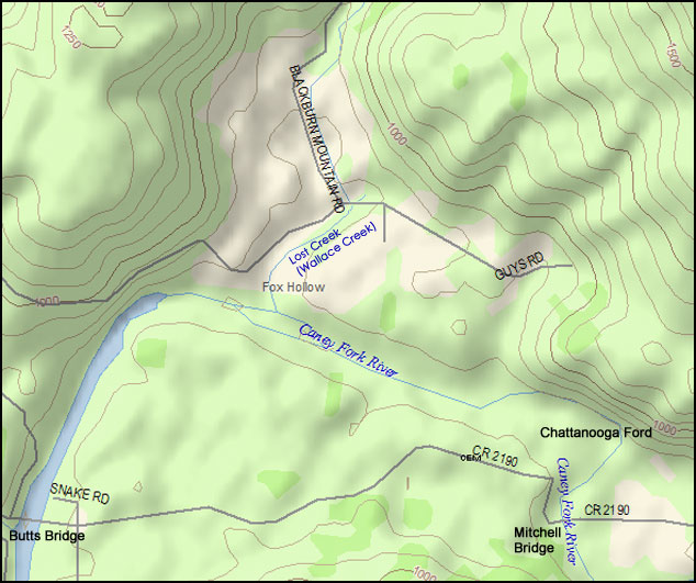
Rush Spring Creek |
|
See
Lost Creek in the list of Caney Fork tributaries and sketch
below.
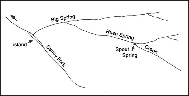
Website Editor's Note: See a modern
topo map of this same area.
The names and sketch of the streams do not match the features of
the area around the
"Lost Creek" stream that flows into the Caney Fork above Butts
Bridge and below the Chattanooga Ford.
If you have information concerning these streams, please contact
Wayne Haston. |
| |
|
Salt Petre |
|
This was to be found in many areas adjacent to the Caney Fork.
There was a Salt petre works operated by Samuel Mollers in Big
Bottom prior to 1819. It was on the Moody Wilson or T. Davis
place. It has been mentioned in Bone Cave
on a preceding page. It was widely used in the manufacture of
gun powder. |
| |
|
Scoggins Shoals |
|
On
the Caney Fork River above the present bridge (Hodges) on the
Doyle-Spencer Road. It was mentioned in a grant of 3500 acres
to Hodge. Many families of this name were living in Middle
Tennessee in the first part of the (19th) century. |
| |
|
Shake Rag |
|
The area west of the Narrows and Power House. The name was
still in common use in 1930. The Rock Island State park is in
this area. |
| |
|
Shippingsport |
|
At
the head of navigation on the Caney Fork and in the vicinity of
Bailiff Ferry. |
| |
|
Simmons, Solomon |
|
The first grant issued for land around the mouth of Calfkiller
River was made to Simmons. It is another familiar name in that
part of Tennessee today. |
| |
|
Singer Sewing machine Company |
|
See Walling, Thomas. |
| |
|
Slatton, Joe |
|
Joe was a native of Van Buren
County, born close to Rocky River, and who lived in the Rock
Island village for many years. He was a loyal helper as rodman
and axeman on surveys and knew the people in the area well.
When the writer started the
reservoir survey in 1923 Joe asked for a job, and we had to tell
him the axeman's job had been filled, but if we had an opening
he could have it. We left camp on Monday each week, spent the
nights at the nearest farm house and returned to Rock island
Saturday night. It was all walking with a small pack and our
instruments.
On
the third Monday out we had finished our lunch in a small
clearing in a dense canebrake, and so the writer said, "Well,
let's get on the move." Sam, the axeman said, "I'm not moving
unless I get a raise in pay right now - today." He thought he
had us trapped, and we would have to give him a raise or return
to camp. He was told he could start back to camp and collect
his pay. Then I saw two hands come through and part the cane,
and Joe stepped into the clearing, saying, "Hi, Mr. Crouch, I
was passing by this way and just thought I'd stop and see if you
had a job open." He had a small pack of clothes on his back.
Later in the day the writer asked Joe how he happened along. He
grinned and said, "I heard Sam bragging at the Bone Cave Store
Saturday night as to how he was going to make you give him a
raise, so I've been following you all since six this morning -
keeping just out of sight. Joe worked off and on for 11 years. |
| |
|
Stony Point School & Church |
|
In
Van Buren County near the Caney Fork and upstream from Dry
Branch. They were mentioned in a deed of 1888. |
| |
|
Stypes Branch |
|
A
very small stream on the right bank of Caney Fork above the
mouth of Calfkiller River. |
| |
|
Sugar Orchard |
|
Name of a place on the left bank of Collins River 9 miles above
the mouth. |
| |
|
Sulfur |
|
Yellow sulfur was to be found in small quantities in the bluffs
along the upper Caney Fork and tributaries. It appeared in thin
seams in the rock many times not more than 1/4 of an inch thick. |
| |
|
Tandy's Knob |
|
This is a high knob on the edge of the Cumberland Plateau above
Bone Cave, from which the Caney Fork and all the roads in the
valley could be seen. During the Civil War Tandy Slatton, Joe
Slatton's uncle, served as a lookout to warn the men making
powder in Bone Cave below, if any Yankee troops appeared in the
neighborhood. |
| |
|
Taverns |
|
Old taverns in the upper Caney Fork area - See the following in
this section: Bouldin House,
Jesse Coffee House,
Hammond Tavern,
Hill's Stand,
Martin's Tavern,
Poplar Tavern, and
Stephen Winton's House. |
| |
|
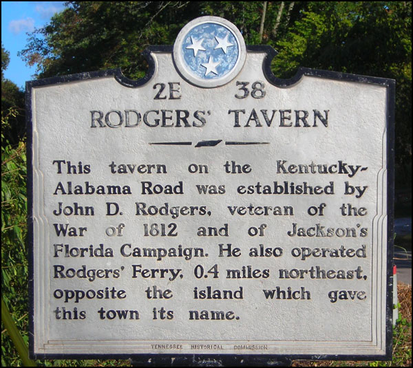
Terry, Joseph |
 He
was the first settler at Rock island. He built a one-room log
house with one door and no windows on the Warren County side of
the river opposite the Island. It had a rough stone chimney
which was still standing in 1915 when the first dam was built.
The cabin had been gone for many years. The Court for White
County met at Terry's house September 11, 1806 in accordance
with the designation made by the General Assembly of Tennessee. He
was the first settler at Rock island. He built a one-room log
house with one door and no windows on the Warren County side of
the river opposite the Island. It had a rough stone chimney
which was still standing in 1915 when the first dam was built.
The cabin had been gone for many years. The Court for White
County met at Terry's house September 11, 1806 in accordance
with the designation made by the General Assembly of Tennessee.
Website Editor's
Note: This sign was once located on Highway 139 (also, now
called the Old Sparta-McMinnville Road, which was formerly
US70S) in front of the Rock Island post office. It is now
in the hands of Dyer Grissom who rescued it from a ditch near
where it once stood before being hit by an automobile. Mr.
Grissom and Mr. Haley are working in tandem with the Tennessee
Historical Commission to get it replaced. 14 Sept. 2002.
Source:
http://www.usgennet.org/usa/tn/county/warren/hm-a-histmarks.html
|
| |
|
Venus Falls |
|
On
Barren Creek which flows into the Caney Fork at Bailiff Ferry.
The falls are about 1/2 mile above the mouth of the creek. |
| |
|
Wallace Branch |
|
See Lost Creek. |
| |
|
Walling, Jere |
|
He
was an old time surveyor who did a lot of work in the upper
Caney Fork area. Prior to 1912 he made a level by mounting a
bottle of water with one air bubble in it on a board - which in
turn was mounted on his Jacobs Staff. Using this he ran a line
of levels up Collins River for Fielding Yost. Later surveys
showed that his error in 12 miles was very small. |
| |
|
Walling, Thomas |
|
The village of Teeter's Cross Roads was named after him. He
lived in Walling and was a timber buyer for the Singer Sewing
Machine Co. He bought black walnut, and when it became hard to
find he bought walnut stumps and white oak. He had a yard at
Rock Island. Most of the timber was floated down the Caney Fork
and caught by a log boom at the Island, and then hauled up the
hill to the Rock Island Railroad Station. |
| |
|
Winton, Stephen House |
|
On the north side of the Old
Kentucky Road about 2.5 miles west of Viola. |
| |
|
Winchester Road |
The section of the Old Kentucky Road west of McMinnville was
often referred to as the Winchester Road, Fayetteville Road, or
Huntsville Road.
|