|
David
Haston Family (1802-1806)
"East Fork of
Grassy Creek"
Summary of the Evidence Stated Below
|
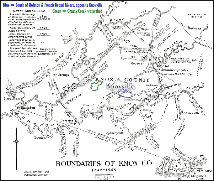
Where did David
Haston's family live in Knox County, TN?
From October 28, 1802 to
September 11, 1806, David Haston owned 111 acres in the
western part of Knox County, TN. His land was clearly
described as being on the "East fork of Grassy Creek." That
would indicate that his land was somewhere in the eastern section
of the Grassy Creek watershed area. We assume that he lived
on this land during the four years that he owned it, just prior to
his move to White County, TN. |
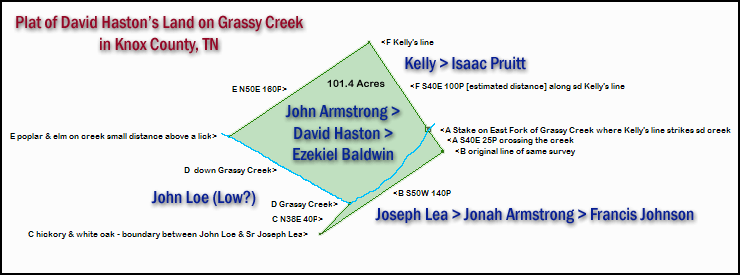
David Haston's Grassy Creek Land
Documents On October 28, 1802, David Haston
purchased 111 acres in Knox County, TN from John Armstrong. The
location of David's land was described by these identifying features:
-
lying and being in the County of Knox
and State aforesaid [Tennessee]
-
on the East fork of Grassy Creek
-
adjoining Jonah Armstrong on the
lower part where Joseph Lea formerly lived
-
and Isaac Pruet on the upper
part formerly held by Kelly
-
Beginning as flows at a stake on the
bank of the creek at the same place where Kelly’s line strikes
said creek
-
thence south forty degrees East twenty
five poles crossing the creek more or less crossing the creek to the
original line of the same survey
-
thence along that line South fifty
degrees West one hundred and forty poles more or less to a hickory and
white oak agreed upon as boundary between John Low (Loe) and
the Sr Joseph Lea
-
thence north thirty eight degrees East
forty poles more or less to the creek -
-
thence down said creek to a poplar and
elm on the bank of said creek a small distance above a (lick?)
-
thence North ca. fifty degrees East one
hundred and sixty pole, more or less to Kellys line -
-
thence along that line South forty
degrees East to the Beginning.
On September 11, 1806, David Haston
sold this 111 acres in Knox County, TN to Ezekiel Baldwin. The
location of David's land was described by these identifying features:
-
lying and being in the County of Knox &
State of Tennessee on the East fork of Grassy Creek,
-
adjoining Francis Johnson on the
lower part where Joseph Lea formerly lived
-
and
Isaac Pruit on the upper
part formerly held by Kelley
-
Beginning as follows at a Stake on the
Bank of the Creek at the same place where Kelleys line strikes
sd Creek
-
thence south forty degrees East twenty
five poles crossing the Creek more or less to the original line of the
same survey
-
thence along that line South fifty
degrees west one hundred and forty poles more or less to a Hickory &
white oak agreed upon as a boundary between John Loe and the
said Joseph Lea
-
thence north thirty eight Degrees East
forty poles more or less to the Creek,
-
thence Down said Creek to a Poplar &
Elm on the Bank of said Creek a Small Distance above a Lick,
-
thence north fifty Degrees East one
hundred and Sixty poles more or less to Kelleys line,
-
thence along that line South forty
degrees east to the Beginning

Some Families of the General
Grassy Valley Area
of Early Knox County, Tennessee
The common denominator for most, if not
all, of the families on the following chart is that they lived in the
same general area of the west-northwest area of Knox County, TN.
Some of these families later moved to the same general area of White
County, TN, at about the same time. There were numerous
inter-marriages between and among these families.
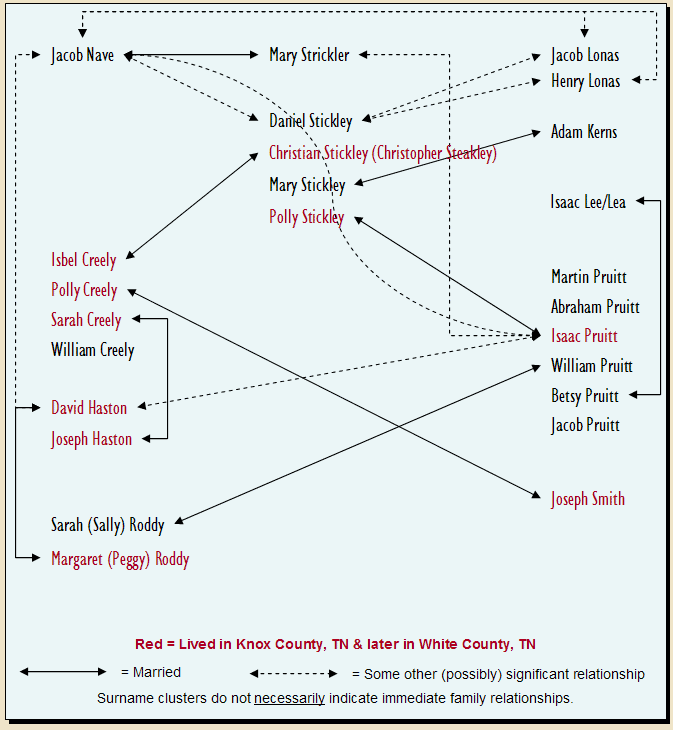
For more detailed information on the above families, go
to the
"Miscellaneous Family Relationships, Knox County, TN - White County,
TN" page.

|