|
Henry
Heestant's Lancaster County, PA Land


|
What We Know
About Henry Heestant's Land in
Hempfield Township of Lancaster County, PA
Five Steps in the
Process of Receiving a Land Patent
Major source: Pennsylvania
Land Records, A History and Guide for by Donna Bingham
Munger (New York: SR Books, 1991).
Note: Black text summarizing the five steps was
written by Wayne Haston, as well as the red text which
specifically reports on his 2017 research at the PA
State Archives related to Henry Heestant's 226 acres in
Hempfield Township of Lancaster County, PA. The
text in blue was written by the Archivist, Aaron
McWilliams in response to his review of the information
in this "What We Know" section.
-
Application -
The application was an individual's request for a
warrant. Between 1732-1765 the request was either
written on a small scrap of paper or added to a longer
list with other requests. But in the earlier
years, it would not have been unusual for the request to
have just been verbal and not written. The
application included the number of acres and general
location desired. In this era, warrants most often
were for surveys of tracts not yet settled and improved.
But sometimes a warrant was issued to accept a survey
for a tract that had already been settled. Many,
but not all, of the applications for the 1732-1765
period are still available in the PA State Archives.
We have not found an
application for the 226 acres surveyed for Henry
Heestant. This may indicate that Henry's request
was only verbal and not written. Or, it may
indicate that Henry did not submit an application to the
Land Office.
-
Warrant - The land
warrant was a document issued by a legal official to
conduct a survey for a tract of land. There were
three types of surveys: (1) warrant to survey,
(2) warrant to accept a survey that had
previously been done, and (3) warrant of entry to
assume a warrant that had previously been granted to
another person.
We have not found a
warrant issued to conduct a tract survey for Henry
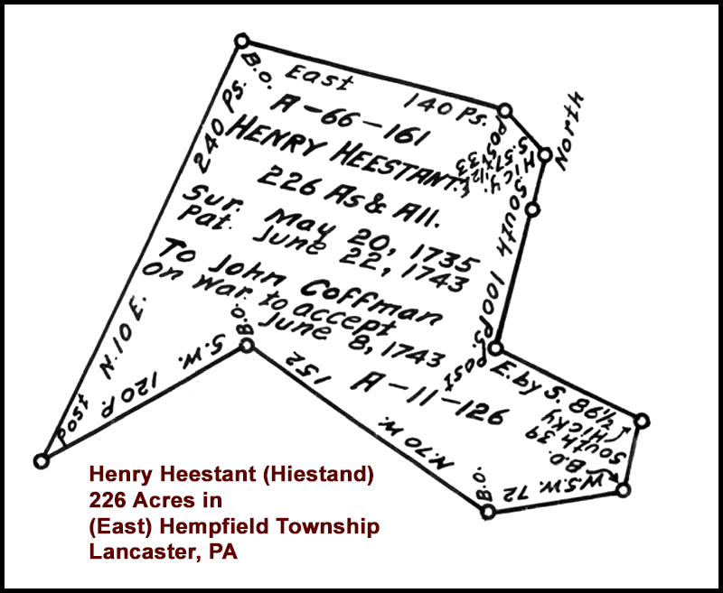
Heestant, yet the May 20, 1735 survey (above) was
clearly done for him. This may indicate that Henry
simply paid a surveyor to survey the land, but did not
make an application through the Land Office.
A warrant (#196) for the 226 acres surveyed for Henry
Heestant was issued on behalf of John Coffman on June 8,
1743 and returned on the same date. As you can see
indicated on the survey, the warrant to John Coffman was
a warrant to accept the survey conducted for
Henry Heestant.
If Henry Heestant's survey had not
been authorized by the Land Office in 1735, would the
Land Office have accepted it as valid in 1743?
Response
from archivist at PA State Archives in Harrisburg, PA:
Yes, it could have. So long as no issues with the survey
were found, it could have been accepted without an
initial application or warrant authorizing the survey.
-
Survey - The
survey document was a visual description of the tract of
land defined by its boundaries. A deputy surveyor,
with a crew of axmen and chainmen, worked under the
authority of the surveyor general's office. The
deputy surveyor drew the plat on a piece of paper,
noting adjoining owners and markers and, after pocketing
one third of the surveying fee, signed the survey and
sent it and the remaining fee to the surveyor general's
office. The surveyor's calculations were checked
in the surveyor general's office where the survey was
then filed. Original surveys were later copied and
bound into books.
The survey (above) is
the only Lancaster County land document that we have
been able to locate with our Henry Heestant's name
associated with it.
-
Return of survey -
The survey return restated in paragraph form the
application or warrant and the survey, with all the
information needed to fill out a patent. The
return of survey also noted the amount of purchase
money, the name of the patentee, and the date. It
was created and recorded in the surveyor general's
office.
We have not found a
return of survey document associated with the (above)
survey of 226 acres in Hempfield Township for Henry
Heestant.
As per an archivist at the PA State
Archives: As it
relates to the return of survey, there is not one under
Henry Hesstant’s name because he did not pay to patent
the land. It does not mean the survey was not authorized
by the land office. A person could have a warrant from
the land office and survey but not a return of survey or
patent. A return of survey was done when the purchase
price and all outstanding interest and fees had been
paid.
-
Patent - A
land patent is an exclusive land grant made by a
sovereign entity (such as, in the case of colonial
Pennsylvania, William Penn and his heirs) with respect
to a particular tract of land--the first conveyance
title of ownership to land. It is sometimes
referred to as a first-title deed. Deeds, on the
other hand, are documents which transfer ownership of
property after the initial transfer from the original
sovereign land-owing entity to the patentee.
Even though the
226 acres tract was surveyed for Henry Heestant on May
20, 1735, he was ultimately not the patentee for the
Hempfield Township land. John Coffman was granted
the land as the patentee on June 22, 1743, two weeks
after the June 8, 1743 warrant to accept Henry's survey.
The purchase price paid by John Coffman was
35 pounds
and six pence (Pennsylvania money).*
*RG-17 Records of the Land Office - Pennsylvania State
Archives, Harrisburg, PA
Microfilm #17.142 - Patent Books, A and AA Series,
1684-1781; Patent Book A-8, page 277 to patent Book
A-11, page 274.
Note: The information
above in this "What We Know" section was reviewed for
accuracy (February 8, 2017) by Aaron McWilliams,
Archivist for the Pennsylvania State Archives in
Harrisburg, PA. Mr. McWilliams' two comments (blue
text) can be seen in the Warrant and Return of the
Survey sections.


The interval of
time between the May 20, 1735 survey and the June 22,
1743 patent probably indicates that Henry Heestant
(Hiestand) lived on the land during that time but was
unable to (or chose not to) pay for the land. This
raises the question: What did Henry do with the 130
gulden, 2 kopfstuck (14 pounds sterling) that he
borrowed from Caspar
Wistar prior to 1733, which was finally paid to
Wistar in early 1742?
A few months
(September 21, 1743) after a warrant was issued to John
Coffman (June 8, 1743) for the Hempfield Township land,
Henry Hiestand purchased 205 acres from Philip Long in
Orange County (now Page County), VA. The deed for
the Virginia land says that Henry paid 54 pounds, 16
shillings, and 6 pence for the 205 acres.
Thoughts Regarding the Values/Costs of
Henry's Lands in
Lancaster County, PA and Orange
County*, VA in 1737-1743
*Would eventually become part of Page County
Note:
Philip Long
paid 100 pounds (2,000 shillings) for 800 acres
[near Alma, VA on the South Fork Shenandoah River] +
205 acres [land Henry purchased from him,
also on the same river] in 1737 or 1738 in Orange
County, VA.
-
Compare the amount
that Henry paid for the 205 acres in Virginia to the
35 pounds
and six pence [6 pence = 1/2 shilling] that John
Coffman paid for the 226 acres in Lancaster County
in 1743.
-
Why would Henry have
paid 20 pounds more for 21 fewer acres in Virginia
than his 226 acres in Pennsylvania was worth -
especially since Lancaster County land was in
greater demand at the time?
-
Maybe it had
something to do with the fact that the
205 acres tract in Virginia has approximately 1.8
miles of frontage on the South Fork of the
Shenandoah River, whereas the 226 acres in Lancaster
only had a small stream (or "run") running across
its southwest corner.
Deed for the 205
acres in Virginia - download
pages 417-418 and
pages 419-420.
Orange County, VA Deed Book 7, Pages 417-418 and
419-420.
Document on pages 417-418 gives the price of
5 shillings, apparently per acre.
Document on pages 419-420 gives the price of 54 pounds,
16 shillings, and 6 pence, apparently total price.
|


Source of surveys - Pennsylvania
Historical and Museum Commission - Harrisburg, PA
RG-17 Records of the Land Office
Copies Surveys, 1681-1912
 |